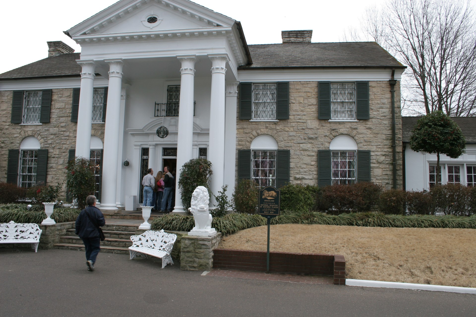
Whitehaven is a neighborhood in the far southwest corner of Memphis, Tennessee, running along Elvis Presley Boulevard toward the Mississippi state line. It is a large, mostly residential district best known nationally as the location of Graceland, but it is also one of the city’s biggest majority-Black neighborhoods with its own commercial corridor, schools and civic identity.
Where are Whitehaven’s boundaries?
Whitehaven sits south of the Memphis International Airport area, bounded roughly by the airport property and Interstate 55 to the north and east, the Mississippi state line to the south, and the Nonconnah Creek corridor to the north. Elvis Presley Boulevard, the local name for U.S. Highway 51, is the neighborhood’s central spine. This puts Whitehaven several miles south of downtown Memphis, closer in distance and orientation to the state line than to the riverfront core most visitors think of first.
Unlike some Memphis neighborhoods that grew up as streetcar suburbs close to the city center, Whitehaven developed as a separate community outside Memphis’s original boundaries and was brought into the city later through annexation. That history still shapes how the area is described in city planning documents, which treat it as a distinct, self-contained district rather than an extension of Midtown or downtown.
How did Whitehaven get its name?
The name predates the modern neighborhood. It comes from White Haven, a 19th-century plantation associated with the family of Colonel Francis Routh in what was then rural Shelby County. The name persisted through the area’s transition from farmland to a country community and eventually to a streetcar-and-highway suburb built around the road south toward Mississippi.
Whitehaven remained an unincorporated community for much of the 20th century before it was annexed into the City of Memphis, a step that brought it under city services and city planning jurisdiction rather than leaving it governed as a separate county enclave. Local histories and city records tied to Memphis’s annexation program are the source for this timeline, and readers wanting exact dates should consult the Memphis and Shelby County Room, the local history archive at the Benjamin L. Hooks Central Library, which holds primary documentation on Shelby County’s older communities.
Why is Whitehaven known for Graceland?
Graceland, the home Elvis Presley bought in 1957 and lived in until his death in 1977, sits directly on Elvis Presley Boulevard in Whitehaven. It is by far the neighborhood’s best-known landmark and the reason Whitehaven appears on world maps at all. The mansion, its grounds, and the surrounding visitor complex are described in full in Access Memphis’s guide to what Graceland actually is and what visitors see there, including how the estate operates today and what is included in a visit.
Graceland’s presence has shaped Whitehaven’s economy for decades. Elvis Presley Boulevard’s commercial strip, its hotels, and much of the area’s tourism-facing business exist because of the estate’s draw, even though the residential blocks around it function as an ordinary Memphis neighborhood with no particular connection to the tourist traffic passing through.

What is Whitehaven like as a neighborhood today?
Whitehaven is one of Memphis’s larger and more populous neighborhoods, with a long-established Black middle-class and working-class population and its own high schools, churches and shopping areas along Elvis Presley Boulevard and Shelby Drive. The city’s Memphis 3.0 comprehensive plan, the planning framework adopted by the City of Memphis Division of Planning and Development, identifies Whitehaven among the city’s major neighborhood centers, reflecting its size and its concentration of retail and civic institutions relative to more purely residential areas nearby.
The neighborhood is also home to Whitehaven Community Development Corporation, one of several Memphis nonprofit CDCs working on housing and commercial revitalization along the boulevard corridor. Readers researching current civic projects, business investment, or neighborhood association activity should treat any specific program details as something to confirm directly with the city or the CDC, since this kind of local initiative changes year to year.
Compared with neighborhoods built around a single historic event or industry — Soulsville and its connection to Stax Records, for instance, or Orange Mound’s history as one of the first Black communities in the country built by and for Black residents — Whitehaven’s identity is less singular. It is a large, ordinary residential district that happens to contain one of the most visited private homes in the United States.
How does Memphis International Airport relate to Whitehaven?
Memphis International Airport borders Whitehaven to the north, and the two areas are frequently discussed together in city planning and economic development contexts because of their shared geography along the I-55/Elvis Presley Boulevard corridor. The airport is a significant employer for southwest Memphis generally, and its presence is one reason this part of the city developed hotel and highway-commercial density earlier than many other outlying neighborhoods.
For anyone planning transport in this part of the city, the practical detail — bus routes, airport shuttle arrangements, road access — is the kind of information that changes with schedules and construction, so it is worth checking current routes through the Memphis Area Transit Authority’s own site or the guidance in Access Memphis’s Getting Around category rather than relying on a fixed description.
Is Whitehaven worth understanding beyond Graceland?
Yes, in the sense that Whitehaven functions as a full neighborhood — with its own schools, churches, retail corridor and civic organizations — independent of the millions of visitors who pass through each year for the Presley estate. Understanding Whitehaven means understanding that Graceland is a landmark located within a working Memphis community, not a theme district built around it.
Readers approaching Memphis primarily as a place to live, rather than visit, will find Whitehaven discussed in broader terms — housing stock, schools, commute patterns — in Access Memphis’s Living in Memphis hub, which covers how Memphis neighborhoods actually function day to day rather than as sightseeing stops.
How does Whitehaven compare with other Memphis neighborhoods?
Whitehaven is geographically separate from the neighborhoods most visitors associate with historic Memphis — Midtown, Cooper-Young, or the districts closer to the river. It sits apart both in distance and in the era it was built, having developed largely as a mid-20th-century suburb rather than a 19th-century streetcar neighborhood.
For a fuller sense of how Memphis’s neighborhoods differ from one another — in age, layout, and the history that shaped each one — the Neighbourhoods archive and the Memphis Guide hub lay out the wider pattern that Whitehaven fits into: a city made of distinct, separately-founded communities that were later annexed and stitched together into one municipal boundary, each still carrying its own name and its own history.
Access Memphis is an independent guide written from published, checkable sources. We have not visited the places described here and we do not publish personal recommendations or invented ‘local favourites’ — where something is singled out as notable, we say who says so. Opening times, fares, closures and prices change at short notice, so treat everything here as a starting point and confirm with the museum, operator or venue directly before building a day around it. We give no advice on visas, insurance, health or safety; use your own government’s official guidance for those.